FIGURE 1 - MAP OF CAIRNS AREA
What this all means is:
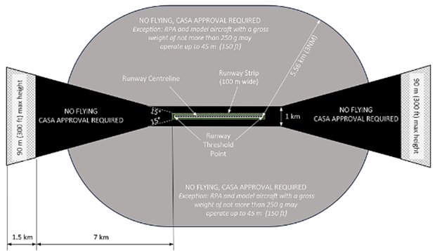
I CAN NOT operate in the Cairns Airport “Bow Tie” template.
I can operate in any clear area on this map up to 400 feet or 120m Above Ground Level (AGL)
I can operate in any of the orange areas up to 400 feet AGL
I can operate in any of the yellow areas but if a helicopter appears I must land immeadiately
I can operate within the hatched tips of the “Bow Tie” boundary but I require
CASA approval, which may take approx 1 month to obtain, AND
Not above 300 feet or 90 meters AGL, AND
I must be listening to Air Traffic Control Frequency (2 way radio)
I can operate within the pink oval up to the “Bow Tie” boundary but I require
CASA approval, which may take approx 1 month to obtain, AND
Not above 150 feet or 45 meters AGL, AND
I must be listening to Air Traffic Control Frequency (2 way radio)